Mining & Hills Survey
Mining & Hills Survey
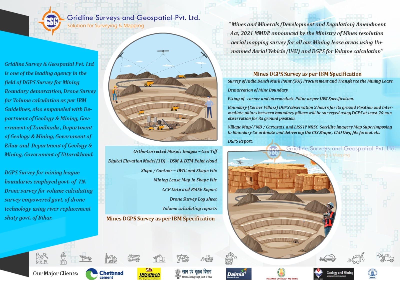
- Mine Boundary’s Demarcation & DGPS Survey & Cadastral Map Digitations Incorporate in Satellite Image As Per IBM Specification.
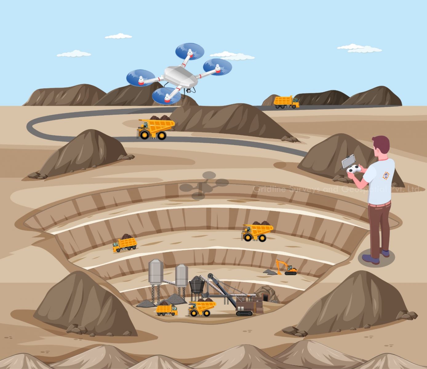
- Drone Survey Mines As Per IBM Specification We have DGCA Approved Drones & Pilots.
- We have Registered Govt of Tamilnadu & Govt of Bihar
- We have Completed 50+ Major Minerals Covering 500 Hectares In Tamilnadu , Two Districts in Bihar
Expert Mining & Hill Survey Services in Chennai – Gridline Surveys & Geospatial
Mining operations and hill terrain projects require an extraordinary level of precision, technical sophistication, and strict adherence to statutory laws. For mine operators, developers, and government bodies, even a minor variance in boundary mapping can lead to severe legal penalties, operational shutdowns, or environmental violations. Gridline Surveys and Geospatial Pvt. Ltd. provides industry-leading, compliant geospatial engineering to execute high-stakes mining and hill surveys with flawless accuracy.
As a premier Mining & Hill Surveyor in Chennai, our firm carries a Government of India Certificate backed by 21 years of rugged field experience in land surveying and complex terrain services throughout India. We provide data that is accurate, legally bulletproof, and meticulously matched to regulatory demands.
Technical Solutions for Mining & Hills Surveys
Mining and hill projects operate under strict legal frameworks. Our specialized mining & hill surveyors in Chennai manage your end-to-end mapping needs using advanced, approved technology frameworks:
Mine Boundary Demarcation & DGPS Survey
Accurate leasehold boundary definition is critical to prevent unlawful extraction and resolve border disputes. We conduct highly accurate Differential Global Positioning System (DGPS) surveys to establish definitive ground control points. Our team ensures all coordinates align perfectly with national grid networks, providing legal peace of mind for mine leases.
-
Cadastral Map Digitization & Satellite Image Incorporation
To meet the stringent mandates of the Indian Bureau of Mines (IBM) Specifications, legacy paperwork is no longer enough. We digitize older paper cadastral maps into precise vector formats and seamlessly overlay/incorporate them onto high-resolution satellite imagery. This gives mining commissioners and leaseholders an undeniable, layered visual proof of land ownership, environmental boundaries, and lease limitations.
-
IBM-Compliant Drone Surveying
Modern mining demands swift, comprehensive aerial insight. Gridline Surveys conducts advanced drone surveys for mines fully configured to IBM Specifications. This enables fast, millimeter-accurate data collection for:
Volumetric Analysis: Calculating precise stockpile volumes, excavation pits, and overburden dumps.
Topographic Contouring: Generating high-density Digital Terrain Models (DTM) and contour maps of steep hill gradients.
Safety & Slope Stability: Monitoring mine wall faces and high benches for structural safety.
Absolute Compliance Safety: We operate with complete legal authority. All aerial operations are executed using DGCA-Approved Drones and licensed, certified commercial pilots, safeguarding your project against regulatory compliance liabilities.
Validated Licensing and Proven Field Experience
Mining surveying cannot be left to unverified operators. Gridline Surveys stands out through official government recognition and an unmatched execution track record across multiple states:
- Government Registrations:
We are officially registered and approved by the Government of Tamil Nadu and the Government of Bihar, clearing the path for fast municipal, state revenue, and mining department approvals.
- Massive Project Track Record:
We have successfully mapped and completed surveys for over 50+ Major Minerals projects.
- Vast Area Coverage:
Our field teams have mapped more than 500 Hectares of complex terrain in Tamil Nadu alongside extensive regional corridor surveys spanning two major districts in Bihar.
Why Gridline Surveys is Chennai’s Choice for Mining & Hills
When looking for a mining & hill surveyor in Chennai, choosing Gridline Surveys ensures your data stands up to the closest official scrutiny:
- 21+ Years of Field Expertise:
Two decades of field operations means we know how to manage severe weather, rocky hill topography, dense forest canopy interference, and high-risk extraction environments safely and efficiently.
- Millimeter Precision Technology:
We eliminate guesswork by combining dual-frequency RTK GNSS receivers, heavy-duty robotic Total Stations, and LiDAR/Photogrammetry data suites.
- Seamless BIM & GIS Integration:
All final deliverables are structured into clean CAD, shapefile (SHP), and 3D point cloud formats, making them ready for immediate upload to state mining portals or enterprise planning software.
Protect and Optimize Your Mining Assets Today
Do not let boundary inaccuracies or non-compliant maps risk your mining lease or infrastructure development timelines. Partner with an experienced, government-registered team that delivers data you can rely on.
© 2023. Gridline Surveys and Geospatial (P) Ltd copyrights. All Rights Reserved. Designed by Justsee