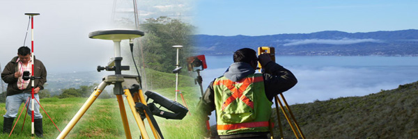
Topographical Survey
Topographical Survey
- Roads
- Railways
- Urban & Rural
- Corridor
- Route Alignment
- Forest
Professional Topographical Survey Services in Chennai – Gridline Surveys & Geospatial
Every iconic infrastructure project, residential development, and transit network relies on an accurate map of the earth's surface before breaking ground. Gridline Surveys and Geospatial Pvt. Ltd. is a premier surveying company delivering high-precision geospatial data across India.
As a qualified Topographical Surveyor in Chennai backed by a Government of India Certificate and 21 years of field experience, we translate complex terrain into highly accurate, actionable 3D data. We leverage advanced tech like high-grade Total Stations, RTK-GPS, and drone mapping to ensure your project's foundation is structurally sound and regulatory compliant.
What is a Topographical Survey?
A topographical survey (or contour survey) identifies and maps the contours of the ground and all existing physical features—both natural and man-made. This includes elevations, trees, water bodies, structures, utility poles, and walkways. For engineers, architects, and project managers, this survey is the literal blueprint required to assess grading, calculate earthwork volumes, and draft safe, structurally sound designs.
Our Specialized Topographical Survey Solutions
Linear infrastructure and landscape modeling demand unique technical approaches. Our seasoned topographical surveyors in Chennai provide targeted expertise across multiple sectors:
-
Road & Highway Topographical Surveys
Designing safe, long-lasting highways requires exact terrain intelligence. We map existing road corridors, elevation profiles, intersections, drainage patterns, and nearby structures. This precision data allows civil engineers to calculate precise cut-and-fill volumes, optimize geometric designs, and plan efficient water runoff management.
-
Railway & Mass Transit Surveys
Railway engineering tolerates almost zero margin for error regarding grades and alignments. Gridline Surveys conducts highly detailed topographical mapping for new rail lines, station yards, and metro corridors. We capture crucial structural clearance data, cross-sections, and elevation profiles to ensure smooth track laying and operational safety.
-
Urban & Rural Land Mapping
Urban Surveys: Navigating congested city environments requires tracing underground utilities, high-rise footprints, and tight boundary constraints for smart city planning or redevelopment.
Rural Surveys: For massive agricultural developments, irrigation networks, or rural expansion, we map vast expanses of open terrain, capturing natural drainage channels, catchments, and village boundaries.
-
Corridor & Route Alignment Surveys
Selecting the most cost-effective and environmentally sound path for pipelines, power transmission lines, or canals is a major challenge. Our route alignment surveys evaluate multiple path options. We analyze the topography to help you avoid costly geographical obstacles, minimize environmental impact, and streamline right-of-way (RoW) acquisitions.
-
Forest & Environmental Surveys
perating in protected or dense forest zones requires technical skill and deep environmental respect. We conduct specialized forest topography surveys to map tree canopies, river streams, ridge lines, and slopes. This data is critical for eco-tourism planning, forest boundary clearing, and compiling Environmental Impact Assessment (EIA) reports.
Why Choose Gridline Surveys in Chennai?
Selecting the right partner for topographical surveying in Chennai can mean the difference between a project finishing on time or facing massive, unexpected engineering overruns.
- 21+ Years of Field Expertise:
Two decades of hands-on experience means we know how to handle challenging coastal terrains, rocky soils, and complex urban environments seamlessly.
- Government Certified:
As a Govt. of India certified entity, our survey reports, contour maps, and data formats comply with the rigorous standards expected by municipal authorities, NHAI, and railways.
- Next-Gen Surveying Tech:
We don't rely on outdated methods. We combine traditional high-precision instruments with advanced LiDAR and aerial drone data processing to deliver rich, highly detailed 3D digital terrain models (DTM).
Secure Accurate Terrain Data for Your Next Project
Avoid costly design errors caused by flawed terrain data. Partner with a trusted topographical surveyor in Chennai to move your project from the drawing board to reality with complete confidence.
Request a Technical Consultation Contact the engineering team at Gridline Surveys and Geospatial Pvt. Ltd. today. Share your project boundaries, and we will provide a comprehensive, tailor-made topographical survey proposal.
© 2023. Gridline Surveys and Geospatial (P) Ltd copyrights. All Rights Reserved. Designed by Justsee