Pipe Line Survey
Pipe Line Survey
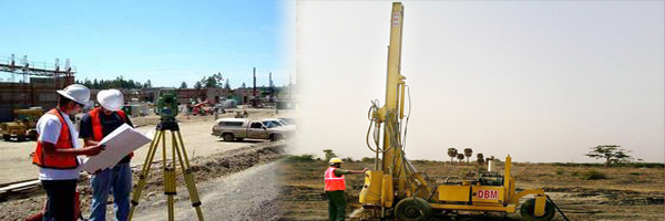
Geo-technical investigation works:
Soil Investigation:
- Boreholes, Plate Load Test Compaction Test.
- We Have Experienced Geo-technical Engineers.
Pipeline Survey
- Right of Way Routing
- Design and Mapping
- Construction Management
- Pipeline Inspection Services
- Pipeline Integrity Management
- Geospatial Services
Pipeline Survey Route Sketch:
- Proposed route alignment design.
- Crossing details ,river, road, canal etc, taking levels preparation drawings, Ls & Cs.
Few of our Completed Works:
- ProposedPowerPlant, Sivagangai Dist, Sai Jyothi Infrastracture Pvt.Ltd.
Comprehensive Pipeline Survey & Geotechnical Engineering Services – Gridline Surveys & Geospatial
Transporting oil, gas, water, or slurry across hundreds of kilometers requires an extraordinary level of engineering precision and geographical planning. Pipelines span diverse terrains, cross critical public infrastructure, and navigate complex geological layers. A minor error in route mapping or soil assessment can result in pipeline stress, environmental leaks, and catastrophic project delays. Gridline Surveys and Geospatial Pvt. Ltd. delivers the specialized engineering, routing, and geotechnical data required to build safe, long-lasting pipeline networks.
As a premier Pipeline Surveyor in Chennai, our firm holds a Government of India Certificate backed by 21 years of active field experience across India. We combine advanced geospatial software with rugged field engineering to support energy utilities, municipal bodies, and EPC contractors through every phase of pipeline development—from initial route sketches to long-term integrity monitoring.
Technical Solutions for Pipeline Engineering
Pipeline networks demand specialized engineering workflows that protect the structural asset both above and below the ground. Our expert teams manage your pipeline projects through targeted technical solutions:
-
High-Precision Pipeline Survey Route Sketches
A successful pipeline begins with an optimized path. We specialize in drafting detailed Pipeline Survey Route Sketches that establish the definitive framework for the proposed network.
Proposed Route Alignment Design: Selecting the most cost-effective path that avoids environmental hazards, minimizes community disruption, and lowers material costs.
Crossing Detail Mapping: Pipelines frequently intersect challenging obstacles. We conduct highly detailed surveys at every river, road, canal, and railway crossing, taking precise elevation levels to ensure structural safety.
Ls & Cs Drawing Preparation: We generate highly detailed Longitudinal Sections (Ls) and Cross Sections (Cs) drawings. These profiles allow pipeline engineers to plan precise bending angles, calculate exact burial depths, and manage fluid dynamics effectively.
-
Comprehensive Geotechnical Investigation Works
The structural safety of a pipeline depends heavily on the soil supporting it. Our team includes highly experienced Geotechnical Engineers who conduct exhaustive soil investigations along the proposed corridor:
Boreholes: Drilling deep exploratory boreholes to identify underground soil strata, analyze rock characteristics, and map water table depths.
Plate Load Test: Measuring the ultimate bearing capacity of the soil to ensure heavy valve stations and terminal structures have stable foundations.
Compaction Test: Evaluating soil density and moisture characteristics to guide contractors on proper backfilling methods once the pipeline is buried.
-
End-to-End Project Lifecycle Management
Right of Way (RoW) Routing & Mapping: Mapping out the exact property parcels intersected by the pipeline. We generate clean land plans that help developers secure regulatory clearances and manage right-of-way acquisitions smoothly.
Design, Mapping & Geospatial Services: Integrating your field survey points into advanced GIS databases. This allows engineering teams to visualize terrain profiles, model slope hazards, and manage assets dynamically.
Construction Management Support: Staking out centerlines and excavation depths on-site, ensuring field contracting crews lay the pipeline precisely according to approved engineering designs.
-
Inspection & Pipeline Integrity Management
Protecting your asset doesn't end when construction finishes. We provide specialized pipeline inspection services and long-term Pipeline Integrity Management. By combining high-definition topography, GPS data, and specialized monitoring workflows, we help operators detect slight soil movements, monitor riverbed erosion near crossings, and flag unauthorized encroachment before it threatens pipeline safety.
Why Gridline Surveys is Chennai’s Trusted Pipeline Partner
Selecting the right pipeline surveyors in Chennai directly impacts your project's safety, compliance, and budget predictability.
- 21+ Years of Proven Infrastructure Experience:
We understand Chennai's unique coastal geology, marshy terrains, and complex urban utility corridors intimately.
- Government Certified standing:
Our official credentials ensure that our route drawings, Ls & Cs profiles, and geotechnical reports carry the absolute legal weight required for government tenders and statutory approvals.
- Advanced Technology Stack:
We eliminate manual error by deploying dual-frequency RTK GNSS receivers, high-precision electronic Total Stations, and industry-standard CAD/GIS software to deliver flawless data packages.
Secure Your Pipeline Corridors with Complete Confidence
Do not leave your route alignments, crossing designs, or soil stability to guesswork. Partner with Chennai's trusted pipeline and geotechnical experts to move your energy or water project from design to reality with complete clarity.
© 2023. Gridline Surveys and Geospatial (P) Ltd copyrights. All Rights Reserved. Designed by Justsee