Setting Out Survey
Setting Out Survey
- Boundary
- Collums
- Pillar Marking
- Layout
- Route Alignment
- Road and Railway
- Transmission
Precision Setting Out Works Survey in Chennai – Gridline Surveys & Geospatial
Moving a project from a digital blueprint to the physical ground is one of the most critical phases of any construction or infrastructure development. A minor math or placement error at this stage can result in massive structural failures, legal disputes, and catastrophic financial losses. Gridline Surveys and Geospatial Pvt. Ltd. provides the high-precision engineering support required to translate your architectural visions into perfectly aligned physical structures.
As a leading Setting Out Works Surveyor in Chennai, we hold a prestigious Government of India Certificate and offer 21 years of field experience. Our surveying teams possess the specialized skills and instruments required to mark out engineering designs on-site with millimeter accuracy.
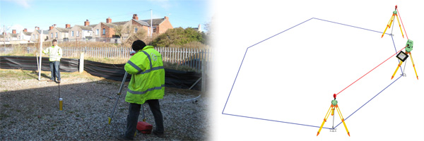
What is a Setting Out Survey?
Setting out is the process of extracting coordinates, dimensions, and levels from architectural or engineering drawings and physically marking them onto the site using pegs, pillars, or paint. This establishes the exact boundaries, levels, and structural gridlines that excavation and construction crews need to follow. Essentially, setting out ensures your project is built exactly where it belongs, precisely how it was designed.
Our Expert Setting Out Solutions in Chennai
At Gridline Surveys, we provide specialized engineering layout solutions for projects of every scale, from residential high-rises to cross-country transit corridors.
-
High-Precision Column & Pillar Marking
The structural integrity of any multi-story building relies entirely on the precise placement of its load-bearing elements. We use high-accuracy Total Stations to perform precise column marking and pillar marking. By establishing perfectly aligned center lines and grid networks, we ensure that columns are perfectly vertical, loads are properly distributed, and foundations match engineering designs perfectly.
-
Comprehensive Layout Demarcation
Before excavation begins, the entire footprint of the project must be clearly defined. We provide comprehensive layout marking for master-planned townships, commercial complexes, and industrial parks. Our surveyors physically plot building lines, parking grids, internal roadways, drainage pathways, and utility connections, allowing your contracting teams to move forward with absolute confidence.
-
Boundary Establishment & Protection
Before structural work commences, establishing the definitive legal edge of your site is critical. We stake out exact property lines to ensure that no part of your building, retaining wall, or temporary construction facility encroaches onto neighboring land or municipal easements, saving you from future legal headaches.
-
Route Alignment for Infrastructure Projects
Linear engineering assets span kilometers and encounter highly diverse terrains. Gridline Surveys specializes in setting out complex route alignments for large-scale infrastructure developments, keeping civil projects on their mathematically designed paths.
-
Road and Railway Engineering Surveys
Road Construction: We set out accurate centerlines, curve radii, cross-section profiles, and grade levels for highways and urban expressways to guarantee smooth transit and proper stormwater drainage.
Railways & Metro Rail: Rail projects demand virtually zero margin for error. We set out precise track alignments, switches, transitions, and station platform boundaries to meet stringent railway safety standards.
-
Transmission Line Tower Marking
Plotting electrical transmission networks requires navigating challenging elevation changes and strict right-of-way constraints. Our surveying teams plot precise tower base centers, structural anchor points, and clearance corridors to facilitate safe, efficient power transmission grid deployment.
Why Gridline Surveys is Chennai’s Preferred Engineering Surveyor
When looking for setting out works survey in Chennai, developers choose Gridline Surveys because we treat accuracy as a non-negotiable standard:
- 21 Years of Real-World Expertise:
Over two decades of on-site experience means our surveyors can easily adapt to complex urban environments, coastal soils, and heavy industrial sites.
- Government Certified Standing:
Our official Govt. of India certification guarantees that our survey practices, baseline benchmarks, and structural transfers align with national engineering standards.
- Advanced Technology Stack:
We eliminate manual error by leveraging automated Total Stations, high-precision digital levels, and dual-frequency RTK GPS receivers capable of absolute coordinate positioning.
Lay the Right Foundation for Your Next Project
Do not leave your construction dimensions to guesswork. Partner with Chennai’s trusted geospatial experts to ensure your roads, columns, and transmission layouts are marked with perfect precision.
Get an Expert Consultation Today Contact Gridline Surveys and Geospatial Pvt. Ltd. to discuss your upcoming construction project. Let our certified engineering surveyors manage your on-site layout and setting out needs.
© 2023. Gridline Surveys and Geospatial (P) Ltd copyrights. All Rights Reserved. Designed by Justsee