LIDAR Survey
LIDAR Survey
Ariel
- Road
- Railway
- Stock Pile and Volume Estimation
- Heritage survey
- Agriculture survey
- Land survey
- Mining survey
- Construction Monitoring
- Videography ,
- Bridge Inspection
Terrestrial
- Scanning Interior building ,Malls, hospitals, etc.
- Heritage Structures As-built data reconstruction
- Fault analysis / Inspection Industrial/plant scanning, Stock Pile ,
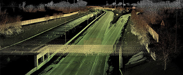
Mobile
- As-built scanning and mapping
- DPR & Highways feasibility study
- Asset Mapping Railways with Detailed design
- Mapping Smart City
Advanced Terrestrial Laser Scanner & Mobile LiDAR Services in Chennai – Gridline Surveys & Geospatial
Capturing complex geometries, dense plant piping, historical architecture, or thousands of kilometers of highway assets using manual measurement methods is an overwhelming operational challenge. Traditional methods often result in missing details, extended field timelines, and high labor costs. Gridline Surveys and Geospatial Pvt. Ltd. eliminates these bottlenecks by delivering cutting-edge, high-speed 3D laser scanning and mobile LiDAR solutions.
As a premier provider of Terrestrial Laser Scanner surveys in Chennai, our firm carries a Government of India Certificate backed by 21 years of field experience in land surveying and advanced geospatial services across India. We convert physical structures into precise, millimeter-accurate digital twins, giving your engineering and management teams the rich 3D data they need to make intelligent, cost-saving decisions.
The Power of LiDAR Technology
LiDAR (Light Detection and Ranging) uses rapid laser pulses to calculate exact distances, creating dense, highly accurate 3D point clouds of the surrounding environment. Our specialized surveying teams utilize three core LiDAR methods to fit your project's unique footprint:
-
Terrestrial Laser Scanning (TLS)
Stationary 3D laser scanning captures complex, highly detailed environments where millimeter-level accuracy is non-negotiable.
Interior Building Mapping: We scan high-traffic facilities like malls, hospitals, corporate offices, and transit hubs to generate comprehensive spatial layouts and asset databases.
Industrial & Plant Processing: We capture dense piping networks, structural steel, and refinery equipment to create accurate intelligent 3D models, simplifying retrofitting and pipe replacement projects.
Heritage Structures & As-Built Data Reconstruction: We preserve history digitally. Our scanners safely document fragile archaeological sites and heritage buildings, creating rich architectural blueprints for restoration or structural preservation.
Fault Analysis & Inspection: We scan structural beams, retaining walls, and industrial elements to detect slight deformations, shifts, or cracks before they risk site safety.
-
Mobile Lidar Scanning
By mounting specialized LiDAR arrays and high-resolution cameras directly onto moving vehicles or railcars, we map extensive transit networks quickly and safely without interrupting traffic.
Highways Feasibility Studies & DPR: We scan road corridors at normal driving speeds to gather rich terrain data for Detailed Project Report (DPR) formulation, alignment adjustments, and pavement analysis.
Railway Asset Mapping & Detailed Design: We map out structural clearance envelopes, tracks, overhead electrical lines, and station assets to streamline modern mass transit upgrades.
Smart City Mapping: We build rich geospatial basemaps for municipal bodies, documenting road furniture, street layouts, and public utilities to support modern urban planning.
As-Built Scanning and Mapping: We deliver immediate 3D evidence of completed roads and infrastructure, confirming they match engineering design plans perfectly.
-
Aerial & Specialized Land LiDAR Solutions
When projects span massive geographic areas, aerial and terrain-specific workflows provide rapid regional analysis.
Mining Surveys & Stockpile Volume Estimation: We scan irregular quarry pits and vast stock piles to provide incredibly precise volumetric calculations for inventory audits and legal compliance.
Construction Progress Monitoring & Videography: Combining detailed point clouds with high-definition aerial footage allows developers to track structural timelines and verify construction accuracy.
Bridge Inspection: We capture hard-to-reach bridge piers, bearings, and soffits, providing safety engineers with precise structural health data without requiring risky scaffolding.
Agriculture & Land Management Surveys: We map vast land holdings, helping operators analyze tree canopy heights, terrain drainage patterns, and property boundary lines.
Why Gridline Surveys is Chennai’s Leading LiDAR Expert
Investing in 3D scanning and mobile mapping requires a partner who understands data processing as deeply as field operations.
- 21+ Years of Geodetic Expertise:
We back up our laser scans with rock-solid ground control points. This ensures your 3D point clouds tie perfectly into real-world coordinate systems like WGS-84.
- Government Certified Standing:
Our official credentials ensure that our final engineering reports, DTM profiles, and CAD models satisfy strict government and municipal audit parameters.
- Advanced Multi-Format Deliverables:
We convert raw laser data into clean, usable formats—including Revit BIM models, AutoCAD drawings, and GIS shapefiles—ensuring seamless integration into your existing corporate software.
Convert Your Site Into a Flawless 3D Digital Twin
Do not let hidden geometric conflicts or slow field measurements stall your engineering timelines. Partner with Chennai's trusted laser scanning and mobile LiDAR experts to capture your project with complete clarity.
© 2023. Gridline Surveys and Geospatial (P) Ltd copyrights. All Rights Reserved. Designed by Justsee